
Singapore's 28 postal districts are a legacy of the old postal system, but they remain the language of the property market — listings, price data and transaction records are all organised by district. The trick for a buyer is not memorising all 28, but understanding how they roll up into the three market regions, because that is how the market actually prices them. For district-by-district detail with notable developments, see the companion page Properties by District, or ask Kris Ang directly on +65 9222 9919.
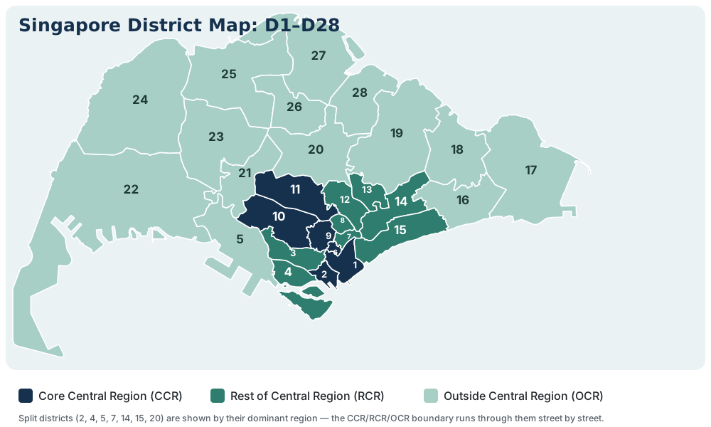
How Districts and Postal Codes Fit Together
Every six-digit Singapore postal code begins with a two-digit sector number, and each of the 81 sectors belongs to exactly one of the 28 districts. That means the first two digits of any address tell you its district instantly: a code starting 22 or 23 is District 9 (Orchard–River Valley); one starting 42 to 45 is District 15 (Katong–Amber). It is a small trick, but it lets you place any listing on the price map before you have even opened it.
The Three Market Regions
Core Central Region (CCR) is the prime tier: all of Districts 9, 10 and 11, plus the downtown and Sentosa parts of Districts 1, 2, 4, 6 and 7. Absolute prices are the island's highest, foreign ownership is most concentrated here, and values are the most cyclical: the CCR falls hardest in downturns and recovers strongest when overseas money returns.
Rest of Central Region (RCR) is the city-fringe belt: Districts 3, 8 and 12 in full, together with the fringe portions of Districts 1, 2, 4, 5, 6, 7, 13, 14, 15 and 20. Pricing sits at a meaningful discount to the CCR for near-CBD convenience, and this is where transformation stories are strongest, a theme I've explored in Buying Ahead of a District's Transformation.
Outside Central Region (OCR) covers the suburban heartlands: Districts 16 to 19, 21 to 28, and the outer portions of Districts 5, 14, 15 and 20. Pricing is the gentlest of the three regions, demand is led by local owner-occupiers rather than foreign money, and performance is historically the steadiest of the three regions. Note the split districts: D15, for example, runs from RCR-classified Marine Parade to OCR-classified Siglap, so two condos in the "same district" can sit in different market tiers.
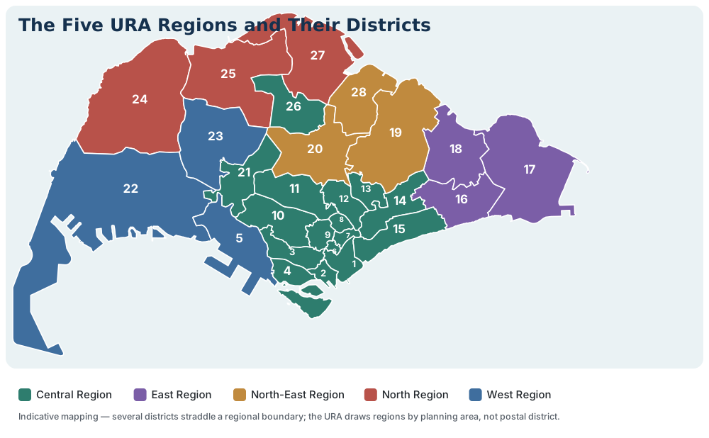
A Second Lens: The Five URA Regions
Alongside the three market regions, you will also see Singapore carved into five administrative regions — Central, East, North-East, North and West — which is how the URA organises its planning areas and how portals often group their district filters. The two systems answer different questions: the market regions tell you how an address is priced; the five regions tell you roughly where it sits on the island.
Full Reference: District, Postal Sectors and Region
| District | Postal sectors | Key areas | Region |
|---|---|---|---|
| D1 | 01–06 | Raffles Place, Marina, Cecil, People's Park | CCR / RCR† |
| D2 | 07–08 | Tanjong Pagar, Anson, Chinatown | CCR / RCR† |
| D3 | 14–16 | Queenstown, Tiong Bahru, Alexandra | RCR |
| D4 | 09–10 | Telok Blangah, HarbourFront, Sentosa | CCR / RCR† |
| D5 | 11–13 | Pasir Panjang, Clementi, West Coast | RCR / OCR† |
| D6 | 17 | City Hall, High Street, Beach Road (part) | CCR / RCR† |
| D7 | 18–19 | Bugis, Middle Road, Golden Mile | CCR / RCR† |
| D8 | 20–21 | Little India, Farrer Park | RCR |
| D9 | 22–23 | Orchard, River Valley, Cairnhill | CCR |
| D10 | 24–27 | Tanglin, Holland, Bukit Timah, Ardmore | CCR |
| D11 | 28–30 | Newton, Novena, Thomson, Watten | CCR |
| D12 | 31–33 | Balestier, Toa Payoh, Whampoa | RCR |
| D13 | 34–37 | Macpherson, Potong Pasir, Braddell | RCR |
| D14 | 38–41 | Geylang, Eunos, Paya Lebar | RCR / OCR† |
| D15 | 42–45 | Katong, Joo Chiat, Amber, Marine Parade | RCR / OCR† |
| D16 | 46–48 | Bedok, Upper East Coast, Eastwood | OCR |
| D17 | 49–50, 81 | Changi, Loyang, Flora | OCR |
| D18 | 51–52 | Tampines, Pasir Ris, Simei | OCR |
| D19 | 53–55, 82 | Serangoon, Hougang, Sengkang, Punggol | OCR |
| D20 | 56–57 | Bishan, Ang Mo Kio, Thomson | RCR / OCR† |
| D21 | 58–59 | Upper Bukit Timah, Clementi Park, Ulu Pandan | OCR |
| D22 | 60–64 | Jurong, Boon Lay, Lakeside | OCR |
| D23 | 65–68 | Hillview, Bukit Panjang, Choa Chu Kang | OCR |
| D24 | 69–71 | Lim Chu Kang, Tengah | OCR |
| D25 | 72–73 | Woodlands, Woodgrove, Kranji | OCR |
| D26 | 77–78 | Upper Thomson, Springleaf, Lentor | OCR |
| D27 | 75–76 | Yishun, Sembawang | OCR |
| D28 | 79–80 | Seletar, Yio Chu Kang | OCR |
† Split districts — the region boundary runs through the district, so individual projects are classified street by street. Always check live transaction data for the specific project rather than relying on district-level generalisations.
Using Districts Well
Districts are a filter, not a verdict — D15 contains both seafront luxury and modest walk-ups; D19 spans landed enclaves and mass-market towers. Use the district to set your search area and price expectations, then judge each project on its own merits: tenure, layout efficiency, and distance to the MRT (on which, see why proximity pays). For the official interactive map, the SLA's OneMap service is the authoritative reference.
Want a shortlist matched to your budget and commute? Call or WhatsApp +65 9222 9919, or use the enquiry form.